


Freezing temperatures to plummet further across UK with snow and ice warnings
Register for free to read more of the latest local news. It's easy and will only take a moment.
The UK will remain in a cold snap until the weekend with freezing temperatures set to plummet even further across much of the country.
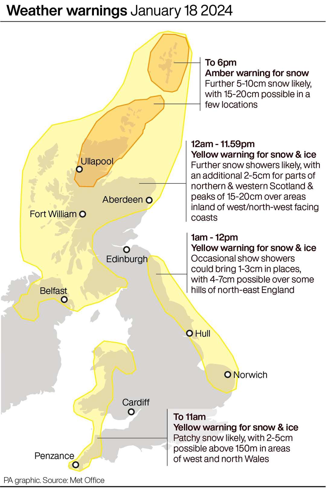
Amber and yellow warnings for snow and ice have been issued by the Met Office across Scotland, where temperatures could fall as low as minus 18C overnight, and coastal areas in England and Wales on Thursday.
If the temperature gets below minus 14.3C it will be the coldest January night since 2010.
Some rural spots of England and Wales could also drop close to between minus 5C to minus 10C with very cold widespread frost.
It comes after the UK had its coldest night of the winter so far which forced hundreds of schools in Scotland to stay closed.
An amber warning for snow across northern Scotland, the Orkney and Shetland Islands is currently in place until 18:00 on Thursday, with the potential of up to 20 centimetres more snowfall.
Parts of Shetland already saw around 23 to 24 centimetres of snow on Wednesday, the Met Office said.
Other parts of Scotland and Northern Ireland have a yellow snow and ice warning spanning the whole of Thursday, while the north and northwest of the UK are likely to see further wintry outbreaks over the next 24 hours.
Separate, shorter snow and ice warnings have also been issued for Wales and southwest England, from 10:00pm Wednesday to 11:00am Thursday, eastern England from 01:00am to midday Thursday, as both areas could see wintry showers that lead to icy patches.
A final yellow ice warning for south east England, in particular south east London, will run until 10:00am Thursday.
Marco Petagna, meteorologist at the Met Office, said: “At the moment we’ve got a northernly air flow and with the sea temperatures being about eight to 12 degrees there is that extra energy around the coasts and that northern wind to get the showers pushing down.
“Because the land temperatures are below freezing there’s not the energy there for the showers to develop, so most of the showers are feeding down in that northernly flow into areas exposed to northerly winds.
“That’s why Scotland, Northern Ireland and the east and west coasts of the UK are seeing most of the showers.”
Conditions will be clearer with more sunshine inland on Thursday and very cold by night under clear skies, Mr Petagna said.
While another frosty night is forecast into Friday it will be breezier with more cloud in places, but lows of minus 10C will again be likely in some areas.
Wind coming in from the Atlantic in the west will then take charge through Friday and into Saturday, bringing much milder, wet and windy weather for the weekend.