


Flood warning as thunderstorms and heavy downpours forecast
Register for free to read more of the latest local news. It's easy and will only take a moment.
Forecasters have warned more heavy downpours could ravage the north-east of England as people were urged to prepare for possible flooding.
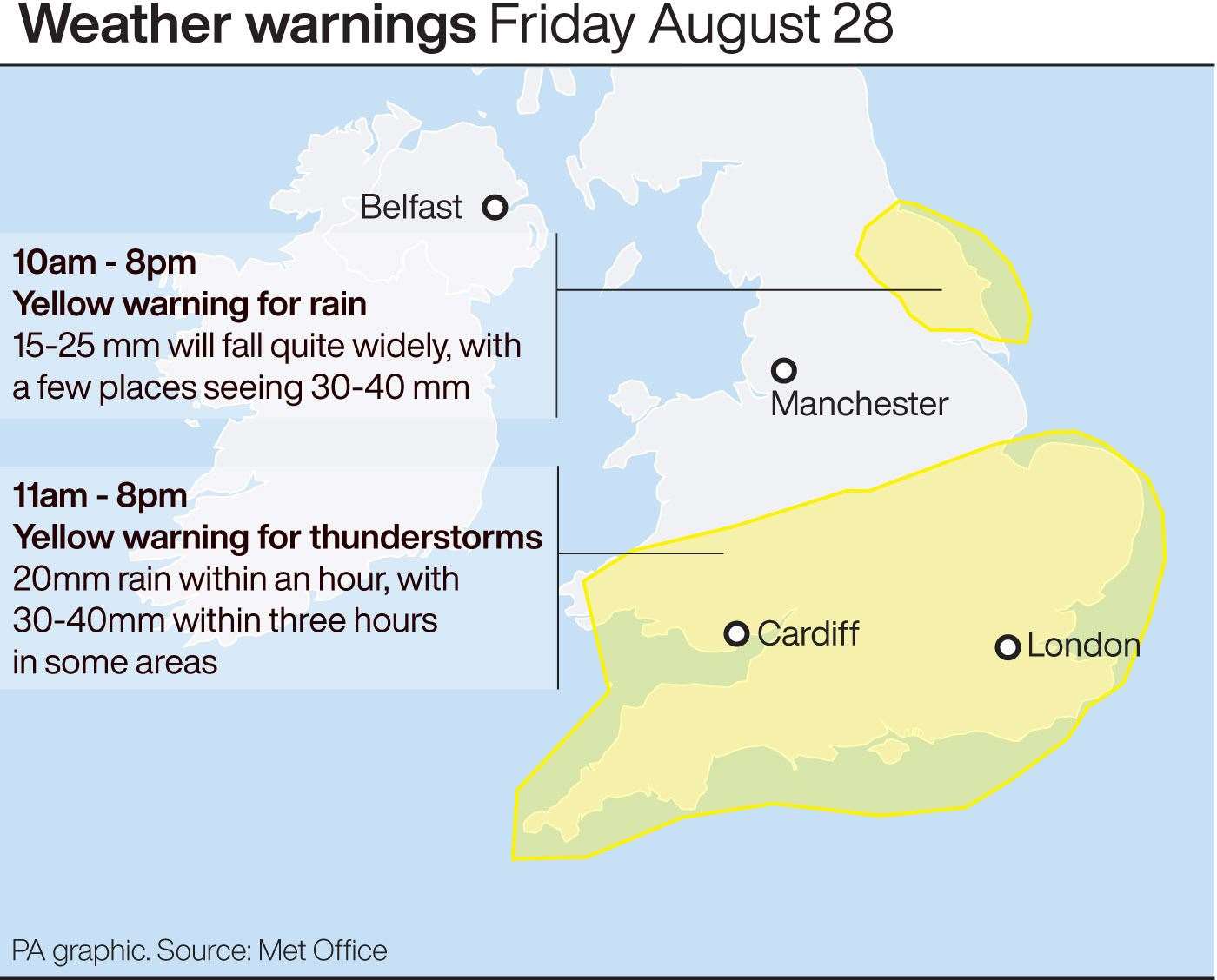
The Met Office extended the yellow weather warning for heavy rain over parts of north-east England on Friday which is expected to last until 8pm.
Forecasters said further downpours could see between 15-25mm of rainfall spread across most of the region, with a few places seeing 30-40mm, particularly across the North York Moors.
With a flood warning issued by the Environment Agency, villagers living in the areas between Briggswath and Ruswarp, near Whitby, North Yorkshire, are being urged to prepare for possible flooding of their homes.
The Environment Agency warned water levels on the River Esk, which runs along the villages towards the North Sea, are rising “quickly” as a result of heavy rainfall overnight and into Friday morning.
It advised people to prepare for possible flooding in their homes by moving possessions and valuables off the ground and to not walk or drive through fast-moving water, as it warned the areas around Ruswarp Pleasure Boats are most at risk.
The warning comes as residents from 14 homes had to be rescued by the Scottish Fire and Rescue Service in Pyothall Court in Broxburn, West Lothian, due to “significant flooding” caused by heavy rain on Thursday evening.
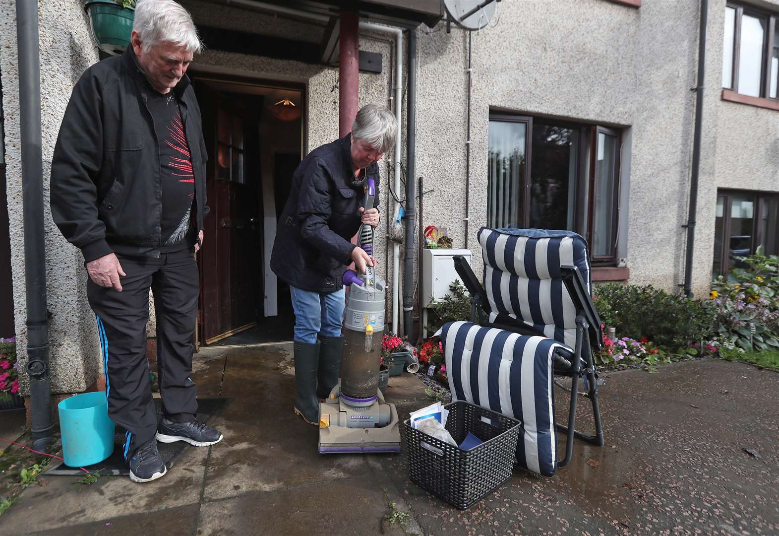
Jean Hendrie, 70, of Pyothall Court, who had to leave her home, told the PA news agency: “One of my neighbours was flooded and the water came right up to her kitchen worktops, and there are cars that are written off.”
Motorists are facing disruption as torrential rain is causing delays on major roads including the M1, M5 and M11, according to traffic data by the AA.
Meanwhile, a yellow weather warning for thunderstorms is in place in parts of southern England and Wales between 11am and 8pm.
Although the Met Office said some places will miss the heavier rain, other locations could see around 20mm within an hour and perhaps 30-40mm in around three hours, which is likely to cause travel disruption.
Speaking to PA news agency, meteorologist Gregory Dewhurst said most of heavy showers will subside overnight and it is unlikely any further weather warnings will be issued this weekend.
He said Friday night will be “quite chilly” with temperatures forecast to dip to around 5C in the north of the UK and around 9C in the south.
On Saturday, more rainfall is forecast to continue in parts of West Wales, Northern Ireland and coastal Scotland, and perhaps some more persistent rain for east England.

Mr Dewhurst said: “The start of the weekend, we are looking at a largely fine day for many but we’ll see showers in the east and west cost of the UK, while inland is more likely to be dry, but much better than what we have seen recently.”
The Met Office said it will be drier and sunnier on Sunday, while it will be noticeably cooler, particularly overnight.
“Sunday will be a dry day across most of the UK, the wind will be lighter,” Mr Dewhurst added.
Throughout the weekend, including Bank Holiday Monday, Mr Dewhurst said temperatures will be between 17-20C across the UK, below the average of 18-23C for this time of year.
Forecasters believe Bank Holiday Monday could be the coldest on record, with temperatures to reach 19C in London while parts of Scotland will be chillier with highs of 11C, well below the average of 16C usually seen in the country.
This contrasts with last year’s late August Bank Holiday Monday which was the hottest on record, with 33.2C recorded at Heathrow.
The recent wet and windy weather is a far cry to what was seen earlier this month, when the UK sweltered on the hottest August day in 17 years on August 7 when temperatures soared to 36C.
“Temperatures over the last few weeks, especially at the beginning of August, were very high,” Mr Dewhurst said.
“We haven’t seen temperatures this cool for quite a while.”